


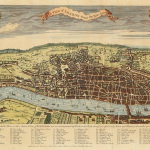


The Agas Map of London, the Great British capital. It is thought to be one of the first recorded, so-called ‘proper’ maps, that meaning a bird’s eye view as opposed to a panorama view of the city, of London. Its creator is believed to be Ralph Agas, and was most likely drawn somewhere between 1570 and 1605. The original version of this plan was over six foot in length and nearly two and a half feet wide in full display. Your stunning replica has been reduced to scale making it of a lot more manageable size, an ideal gift for a loved one or for yourself, as it makes the perfect addition to any home or workplace. Ralph Agas was an English land surveyor and cartographer born in the mid-16th century.
* price shown is for print only


