
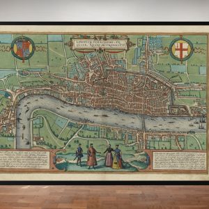
Early Aerial View of London in the 1500’s
Highly recommended this beautifully coloured edition features a fascinating gazetteer detailing almost one hundred points of interest and covering the area from Charing Cross to the west over to Smithfield to the east.


 Braun & Hogenberg’s Old Map of London circa 1570
£29.95 – £39.95
Braun & Hogenberg’s Old Map of London circa 1570
£29.95 – £39.95
 Map of London 16th Century (The Agas Map)
£29.95 – £39.95
Map of London 16th Century (The Agas Map)
£29.95 – £39.95
Early Aerial Map of London
£29.95 – £39.95

Early Aerial Map of London
£29.95 – £39.95


