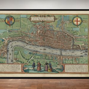
One of the oldest maps from our series drawn by the Deutsch cartographer, Frederic De Witt. With the River Thames running through the centre, the plan depicts the Great British capital in high detail. De Witt was based principally in the capital of the Netherlands, Amsterdam, but his drawings and paintings stretched far beyond the Deutsch borders and included a number of world atlases, which comprised anything from 17 to 151 maps each. Interestingly, De Witt’s maps are notoriously difficult to date as, more often than not, no dates were recorded on his work and the dates of publication extended over many years. De Witt is known to have produced at least 121 atlases and over 1,000 loose leaf maps.
Size: 24″ x 28″
* price shown is for print only