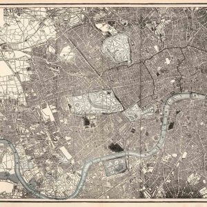
A stunning traveller’s map of Victorian London dated from 1890. The plan depicts high detail of the Great British capital covering from West Kensington across to the West India Docks in the east, and from Hampstead down to the now trendy North Brixton and Camberwell. The map has been illustrated by Bacon with astonishing detail throughout, noting streets, significant buildings, trains, ferries and docks. Particularly poignant are the parks which offer fantastic detail on the interior. The map was originally published from the American cartographer’s office at 127 Strand, London. Having been declared bankrupt in 1867, Bacon re-opened his publishers in 1870 and it soon prospered. Amongst his other work he also produced medical booklets and sold sewing machines.
* price shown is for print only