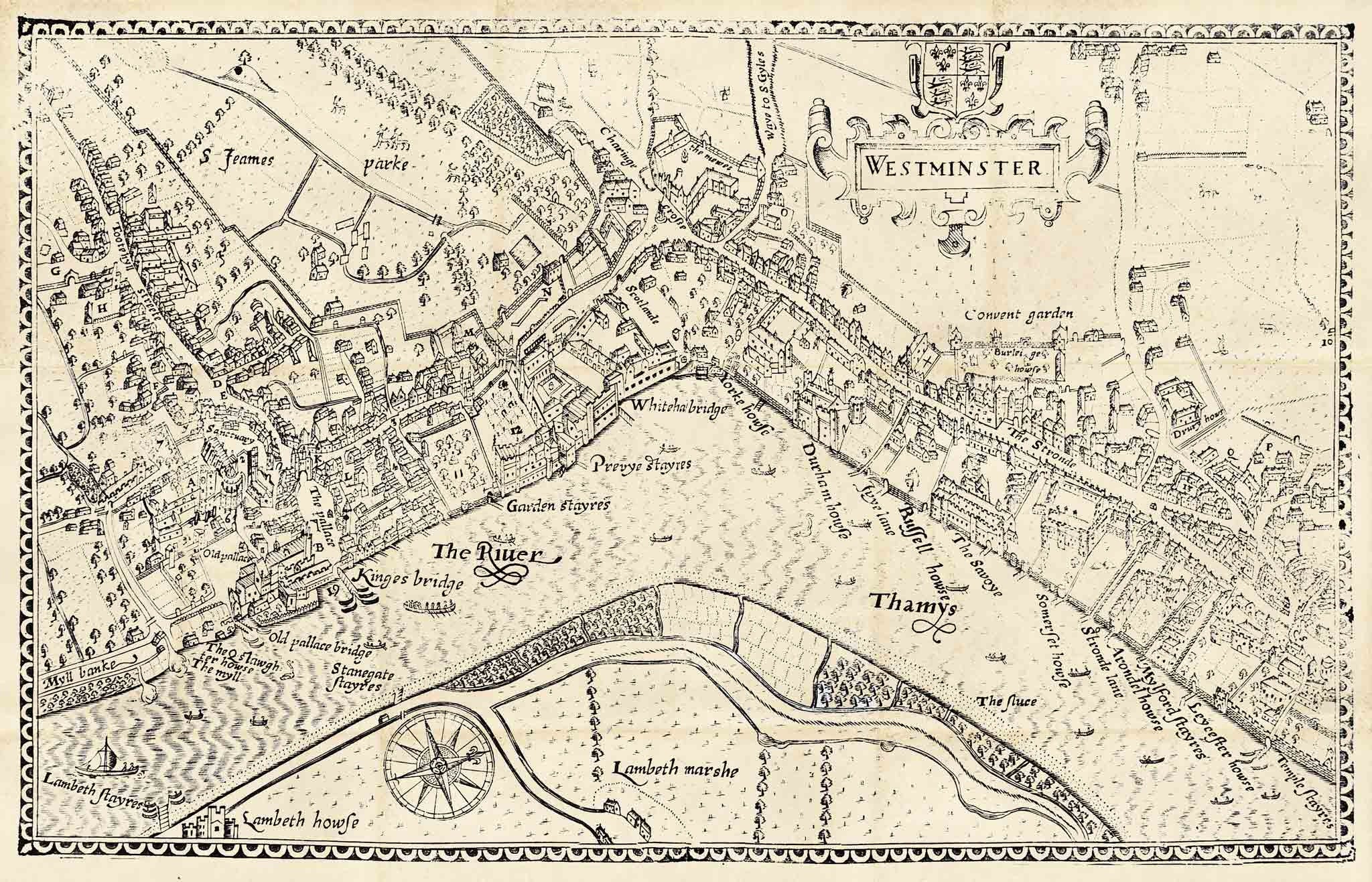


John Norden’s Westminster plan belongs to his Speculum Britanniae project, which combined maps with descriptions of places. The original map dates from 1593. Its pictorial buildings, riverside landing places and open ground make it a particularly engaging record of Elizabethan Westminster.
Map Details
- Original title: Westminster
- Mapmaker: John Norden
- Original engraver: Pieter van den Keere
- Original publication: London, 1593, in Speculum Britanniae: the Middlesex volume
- Area shown: Westminster, Whitehall, the Strand and the opposite Lambeth bank
- Format: Engraved pictorial town plan
- Image source: Wellcome Collection, M0012962, a photograph of the map from a British Museum copy of Speculum Britanniae
Palaces and houses beside the Thames
The map gives substantial buildings individual shapes and names. Whitehall, the older palace area and the large houses along the Strand occupy much of the northern riverbank. Between them, narrower streets are lined with smaller buildings. This pictorial approach helps the viewer read the relationship between royal Westminster and the neighbouring residential district.
Several labels repay a closer look. “Convent garden” lies behind the Strand, with “Drury howse” nearby. The Savoy and Somerset House face the river. These familiar names appear within a setting of gardens, open plots and shoreline houses, rather than the continuous streetscape seen today.
A river reached by stairs
The water is dotted with boats and lined with named landing places. Whitehall’s “Privye Stayrs” and “Garden stayres” are especially clear. Elsewhere the labels attach stairs to individual houses and riverside locations. The map makes those points of access part of its geography, showing how closely the buildings were connected to the Thames.
Across the river, the area labelled “Lambeth marshe” is largely open. Its fields and trees contrast with the more densely built Westminster shore. St James’s Park provides another open space, with tiny deer visible among the trees and paths.
The map and its photographic source
Wellcome identifies the source image as a photograph made in April 1953 from a British Museum copy of Norden’s 1593 publication. That is the date of the photograph, rather than the landscape depicted. Norden’s maps were subsequently reproduced and re-engraved; the original map’s date and authorship are established, while this photographic record does not specify a later impression date.
Print size: 26″ × 17″. Supplied unframed.