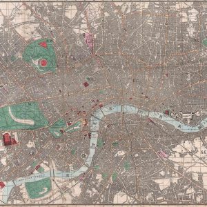

Benjamin Baker’s early 19th century map of London is a stunning image that beautifully encapsulates the Georgian city. The infamous Thames River, open spaces and the city’s boundaries are highlighted by the delicate use of colour that help in bringing the map to life. The plan includes further intrinsic detail such as streets, parks and squares. Other notable cites include Hyde Park, Paddington and Lambeth. This elegant map will make for an astonishing feature in any home or work place as we have worked hard to retain its antique quality making it undefinable from the original to all but a highly trained eye. Originally published by Philips, a well-known publisher of maps that continue to this day, nowadays creating road maps and atlases for more modern use.
* price shown is for print only