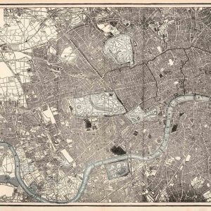
An exquisitely detailed old map of London and its surrounding suburbs illustrated by Gall and Inglis. The map displays an intricately drawn comprehensive plan of the capital, showing even individual buildings, whilst also labelling principle towns, parks and stations. Further to this, there are a number of cycle routes applied in colour to the design. The map was originally published by the two cartographers from their London office at 25 Paternoster Square, although the duo were formally based in Edinburgh. Interestingly, Gall had a series of different business partners including Turnbull and Hay before finally settling with Robert Inglis. Alongside their maps and ordinance surveys, their work comprised novels, textbooks, guides and essays.


 Mogg’s Pocket or Case Map of Old London 1820
£39.95
Mogg’s Pocket or Case Map of Old London 1820
£39.95
 Old map of St. James Clerkenwell 1755
£35.95 – £59.95
Old map of St. James Clerkenwell 1755
£35.95 – £59.95
Old Map of London and Environs 1899 by Gall & Inglis
£29.95 – £39.95

Old Map of London and Environs 1899 by Gall & Inglis
£29.95 – £39.95