


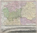
A stunning replica of Homann’s iconic plan of London from the mid-1700s. This old map was strongly designed from an earlier map of the UK’s capital drawn by Thomas Bowles. The illustration depicts London from the county of Berkshire in the west (including the infamous Windsor Castle) across to Shamel in the east, extending north as far as Bedfordshire with particular focus on Surrey, Essex, Kent and Hertfordshire. The detailing throughout this fine example of Homann’s work is astonishing, showing streets, villages, roadways, estates and, often, individual homes. The bottom part of the map displays a striking bird’s-eye view of London and Westminster from Southwark across the River Thames, upon which a number of boats and sailing vessels can be seen.
Image size: 24″ x 27″ (61cms x 68.5 cms) approximate.
* price shown is for print only


