


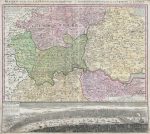
This 1741 sheet combines a regional map with a prospect of London and Westminster. Its subject is the capital’s relationship with the surrounding counties: London occupies a relatively small part of the upper map, while the Thames and the roads linking neighbouring settlements give the wider area its structure.
Map Details
- Original title: Regionis quae est circa Londinum, specialis repraesentatio geographica
- Publisher: Homann Heirs (Homannsche Erben)
- Source map: An English original published by Thomas Bowles
- Publication: Nuremberg, 1741
- Area shown: London and the surrounding counties, including Middlesex, Hertfordshire, Essex, Surrey and Kent
- Format: Copper engraving with a regional map above a panoramic view of London and Westminster
- Orientation: North at the top of the regional map
A county landscape around London
The coloured divisions help readers follow the historic counties, but smaller administrative areas also receive prominent lettering. Names such as Edmonton Hundred, Elthorne Hundred and Becontree Hundred appear within the counties. These hundreds were older local divisions; reading their labels alongside familiar settlements reveals a geographical framework that modern London maps rarely show.
The Thames can be followed through the western part of the map into the capital and eastwards through the wider river landscape. Windsor appears in the west, with Hertfordshire above London and Surrey below it. Villages, roads and local waterways fill the spaces between the larger labels. The map is intended to explain the region around London rather than provide a detailed guide to every city street.
London from the south bank
The lower prospect changes the scale of attention. Viewed from the south, the river becomes a broad foreground to the city, busy with vessels beneath its skyline. The roofs on the Southwark side bring the viewer close to the scene, while the towers and spires across the water identify London as a substantial, densely built capital. The German caption explicitly names both London and Westminster.
An English map for a continental readership
The title acknowledges an English original issued by Thomas Bowles. Both the Bibliothèque nationale de France and the University Library of Bern catalogue this edition as a publication of Homann Heirs in Nuremberg in 1741. The Latin and German headings on the artwork place the familiar London region within the publishing world of continental European atlases.
This combination of county geography and urban panorama is the sheet’s particular appeal. It lets the viewer move between the countryside around London and a river view of the capital itself, rather than looking at either in isolation.
Image size: approximately 24″ × 27″ (61 × 68.5 cm).
Supplied unframed.


