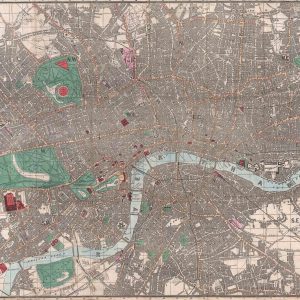

The Environs of London shows how compact the capital remained in 1832 when viewed alongside its surrounding countryside. The street-filled centre is enclosed by a much wider network of villages, estates and roads, with the Thames winding through the landscape rather than simply crossing a city plan.
Map Details
- Original title: The Environs of London
- Draughtsman and engraver: H. Waters
- Publisher: Baldwin & Cradock, Paternoster Row, for the Society for the Diffusion of Useful Knowledge
- First publication: 1 February 1832, London
- Area shown: London and surrounding parts of Middlesex, Surrey, Kent and Essex
- Notable marking: The twopenny post delivery boundary
- Orientation: North at the top
- Print size: 17" × 20"
London within a rural landscape
Richmond Park, the country around Hampstead and Highgate, and the wooded north-eastern area are important parts of the composition. Fine strokes indicate the slopes of hills, while individual settlements are joined by roads that cross extensive open ground. Places now absorbed into Greater London can be seen as separate communities.
The postal boundary
The red circle around central London indicates the twopenny post delivery area. It is a service boundary, rather than a county boundary or the edge of the built-up city. Its inclusion makes this map a record of how London functioned as well as where its streets and villages lay.
The Thames and the Lea
The Thames follows a broad series of bends through the southern half of the sheet, passing Richmond and continuing through London towards Woolwich. The Lea approaches from the north-east. Their courses help explain the arrangement of settlements and the distinction between the crowded capital and its surroundings.
Useful knowledge in print
The Society for the Diffusion of Useful Knowledge commissioned maps intended for a broad educational readership. The clear lettering and detailed treatment of both town and countryside reflect that purpose. The sheet carries its 1832 publication date; examples were also incorporated into later SDUK atlases.